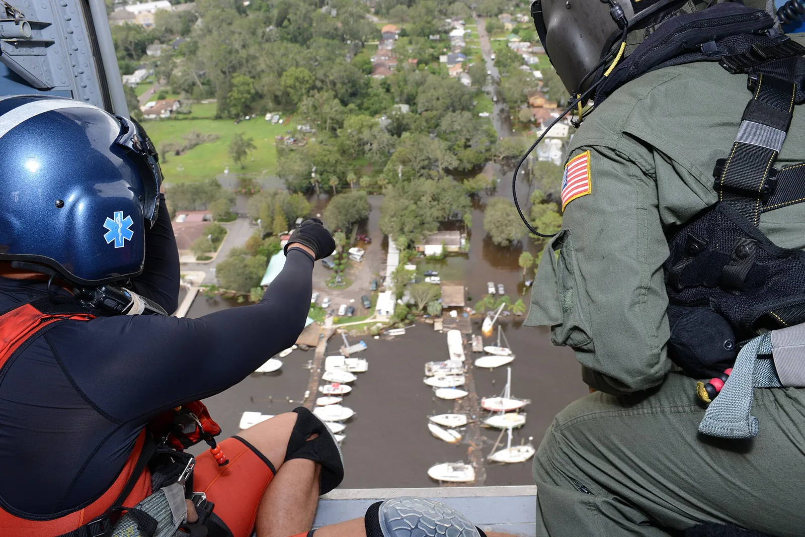
The last coastal flood advisory for Duval was canceled Wednesday, Nov. 4, after more than a week of tidal flooding that reached moderate stage at all eight gauges. Every peak reading.
The run of tidal flooding in Jacksonville is over. The National Weather Service in Jacksonville canceled its last coastal flood advisory for coastal Duval County at 9:23 a.m. Wednesday, Nov. 4. A coastal flood warning was in effect from the weekend of Oct. 24-25. It was canceled at 2:22 p.m. Friday, Oct. 30, and a lesser advisory for minor flooding followed.
Updated Nov. 4: the advisory, set to end at 1 a.m. Monday, Nov. 2, was extended four times, last to 4 a.m. Friday, Nov. 6, then canceled Wednesday morning. A high rip current risk for the beaches runs until 4 a.m. Thursday. Updated Oct. 31: the warning was extended once more, to 5 a.m. Saturday, then canceled Friday afternoon. This page adds the gauge peaks from Wednesday to Saturday and that weekend’s high tide times. Updated Oct. 27: the warning, first set to end at 8 p.m. Monday, Oct. 26, was extended to 2 a.m. Friday.
The advisory as first issued covered the beaches and coastal Duval, the Trout River and the St. Johns River in south-central Duval. The weather service expected minor flooding: “flooding of lots, parks, and roads with only isolated road closures expected.”
How the flooding ended
Every gauge in Duval County reached moderate flooding at least once between Sunday, Oct. 25, and Tuesday, Oct. 27. None reached major flooding. The water then fell a little each day:
- Wednesday, Oct. 28: six of the eight gauges were still at moderate stage.
- Thursday, Oct. 29: four gauges were at moderate stage, all on the St. Johns and Trout rivers.
- Friday, Oct. 30: every gauge was below moderate. Most were at minor stage.
- Saturday, Oct. 31: four river gauges reached minor stage. Fort George, Mayport, Dames Point and Mill Cove stayed below it.
| Gauge | Wednesday | Thursday | Friday | Saturday |
|---|---|---|---|---|
| Fort George State Park | 2.62 ft (moderate) | 2.34 ft | 1.78 ft | 1.43 ft |
| Trout River at Sherwood Forest | 2.62 ft (moderate) | 2.43 ft (moderate) | 2.12 ft | 1.92 ft |
| St. Johns River at Dames Point Bridge | 2.33 ft (moderate) | 2.13 ft (moderate) | 1.79 ft | 1.53 ft |
| St. Johns River at Mill Cove | 2.34 ft (moderate) | 2.15 ft (moderate) | 1.77 ft | 1.55 ft |
| St. Johns River at Mayport | 2.2 ft | 1.95 ft | 1.52 ft | 1.24 ft |
| St. Johns River at Buckman Bridge | 2.17 ft (moderate) | 2.05 ft (moderate) | 1.91 ft | 1.67 ft |
| St. Johns River at Jacksonville | 2.02 ft (moderate) | 1.93 ft | 1.75 ft | 1.57 ft |
| St. Johns River at Main Street Bridge | 1.93 ft | 1.85 ft | 1.68 ft | 1.5 ft |
These are each day’s highest provisional readings, in feet above mean higher high water, from the National Water Prediction Service. Saturday’s figures run to about 6:40 p.m. The flood levels for each gauge are in the table further down this page.
What the warning covered
The warning covered three parts of Duval County, according to the weather service’s coastal hazard message issued at 3:33 a.m. Tuesday:
- coastal Duval, including the beaches and the Intracoastal Waterway
- the St. Johns River basin in south-central Duval
- the Trout River area on the Northside
A high surf advisory for 7- to 10-foot breaking waves ran alongside it. On Thursday, Oct. 29, the weather service extended the warning to 5 a.m. Saturday. It canceled it on Friday afternoon.
How high the water got, Sunday to Tuesday
Every gauge passed its moderate flood level, the weather service’s own threshold for each site. None reached major flooding. Most gauges peaked near the late-morning high tides on Monday and Tuesday.
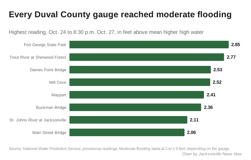
| Gauge | Peak | When | Moderate starts | Major starts |
|---|---|---|---|---|
| Fort George State Park | 2.85 ft | 9:54 a.m. Monday | 2.5 ft | 3.5 ft |
| Trout River at Sherwood Forest | 2.77 ft | noon Tuesday | 2.3 ft | 3.3 ft |
| St. Johns River at Dames Point Bridge | 2.53 ft | 10:42 a.m. Monday | 2.1 ft | 3.1 ft |
| St. Johns River at Mill Cove | 2.52 ft | Monday and Tuesday mornings | 2.1 ft | 3.1 ft |
| St. Johns River at Mayport | 2.41 ft | 10:24 a.m. Tuesday | 2.3 ft | 3.3 ft |
| St. Johns River at Buckman Bridge | 2.36 ft | 11:48 p.m. Sunday | 2 ft | 3 ft |
| St. Johns River at Jacksonville | 2.11 ft | 11:15 a.m. Monday | 2 ft | 3 ft |
| St. Johns River at Main Street Bridge | 2.06 ft | Monday and Tuesday mornings | 2 ft | 3 ft |
Readings are in feet above mean higher high water, the average daily high tide. They are provisional readings from the National Water Prediction Service, taken from Saturday, Oct. 24, through about 6:30 p.m. Tuesday. On Saturday, the first day of the warning, every gauge stayed at minor flood stage.
The Trout River and Mayport gauges read higher on Tuesday than on Monday.
Why the water is so high
This is not a named storm. Strong, persistent northeast winds piled water onto the coast during a run of high astronomical tides, known as king tides. The City of Jacksonville’s Emergency Preparedness Division set out the cause in a release on Friday, Oct. 23.
The city named flood-prone areas along the St. Johns River and its tributaries, including San Marco, Riverside, the Northbank into Hogans Creek and Ken Knight Drive. At moderate levels, it said, water may flow over coastal and riverfront roads near high tide and into low-lying homes and businesses.
What the city is doing
In its Oct. 23 release, the city said the Duval County Emergency Operations Center would move to partial activation Saturday evening. The Jacksonville Fire and Rescue Department positioned swiftwater rescue and road access teams. The Jacksonville Sheriff’s Office planned extra officers and detours around flooded streets, the city said. The city had not posted a newer release on its news page as of Saturday evening.
The Jacksonville Transportation Authority posts any service changes at JTAFLA.com.
What it means for you
- No flood alert is in effect for Duval County as of Wednesday morning, Nov. 4.
- Swim near a lifeguard. A high rip current risk for the beaches runs until 4 a.m. Thursday.
- Report flood damage or a blocked storm drain to the city at 904-630-CITY (2489).
- Sign up for city alerts at JaxReady.com/ALERTJAX.
- Our road closures page has the week’s road work.
Saturday’s readings
When the warning began, all eight gauges reached minor flood stage on Saturday, Oct. 24. None had reached moderate flooding by 9 p.m. that day.
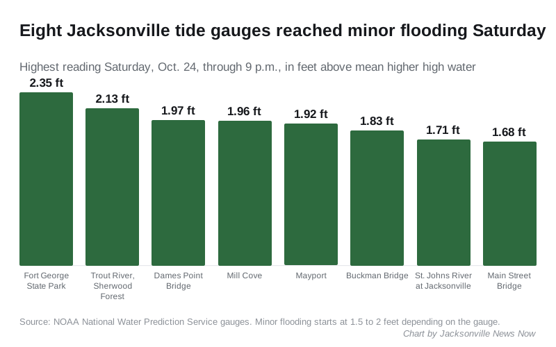
Through 9 p.m. Saturday, readings ranged from 2.35 feet at Fort George State Park to 1.68 feet at the Main Street Bridge.
Have your say