The river reached moderate flood stage Friday night, and a coastal flood advisory runs until 4 p.m. Sunday. High tide times and the creek gauges to watch.
The St. Johns River in Jacksonville reached moderate flood stage late Friday, its highest reading of the week. Minor tidal flooding is expected again at high tide Saturday and Sunday.
The National Weather Service in Jacksonville has a coastal flood advisory in effect until 4 p.m. Sunday. It covers coastal Duval County, the St. Johns River basin in south-central Duval and the Trout River area. The weather service expects “flooding of lots, parks, and roads with only isolated road closures.”
Updated Oct. 10: Isaias weakened over Alabama overnight, and all tropical warnings and North Florida tornado watches have ended.
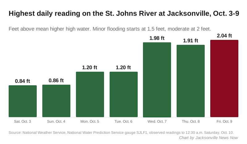
The river gauge reached 2.04 feet at 10:45 p.m. Friday. Moderate flooding there starts at 2 feet. The figures come from the weather service’s St. Johns River at Jacksonville gauge.
The river has risen all week
The gauge stayed below 1 foot on Oct. 3 and 4. It then climbed through the week, reaching the minor flood level of 1.5 feet Wednesday and passing 2 feet on Friday night.
| Day | Highest reading | Flood level |
|---|---|---|
| Saturday, Oct. 3 | 0.84 ft | none |
| Sunday, Oct. 4 | 0.86 ft | none |
| Monday, Oct. 5 | 1.2 ft | action |
| Tuesday, Oct. 6 | 1.2 ft | action |
| Wednesday, Oct. 7 | 1.98 ft | minor |
| Thursday, Oct. 8 | 1.91 ft | minor |
| Friday, Oct. 9 | 2.04 ft | moderate |
Readings are in feet above mean higher high water, the average daily high tide. The weather service sets the flood levels for this gauge at 1 foot for action, 1.5 feet for minor, 2 feet for moderate and 3 feet for major flooding.
Upriver, the St. Johns River at Buckman Bridge gauge on Interstate 295 peaked at 2.13 feet at 11 p.m. Friday. It uses the same flood levels.
Creeks and rivers across Duval County
The weather service’s gauges in Duval County showed these readings between 12:30 and 2:30 a.m. Saturday:
| Gauge | Reading | Flood level |
|---|---|---|
| Thomas Creek | 4.07 ft | moderate (major at 4.5 ft) |
| Julington Creek at Old St. Augustine Road | 1.87 ft | moderate |
| Julington Creek at the St. Johns River | 1.93 ft | minor |
| St. Johns River at Buckman Bridge | 1.89 ft | minor |
| St. Johns River at Jacksonville | 1.68 ft | minor |
| Pottsburg Creek near Jacksonville | 6.47 ft | minor |
| Pottsburg Creek at Beach Boulevard | 1.69 ft | action |
| Cedar River at San Juan Avenue | 1.48 ft | action |
| Ortega River at Argyle Forest Boulevard | 9.5 ft | action |
Each gauge measures against its own reference level, so a reading at one cannot be compared with a reading at another. The flood level column is the weather service’s own category for that gauge. The service had no current forecast posted for these gauges early Saturday.
When high tide comes
Tidal flooding is worst around high tide. The National Oceanic and Atmospheric Administration predicts these high tides:
| Station | Saturday | Sunday |
|---|---|---|
| Mayport, at the river mouth | 9:04 a.m. and 9:18 p.m. | 9:47 a.m. |
| Southbank Riverwalk, downtown | 10:42 a.m. and 10:53 p.m. | 11:27 a.m. |
These are predicted times for the normal tide. Wind and rain can push the water higher and later than the prediction.
Where Isaias is now
Isaias is no longer a tropical storm, and it is moving away from Florida. The National Hurricane Center’s 4 a.m. CT advisory Saturday placed the post-tropical cyclone about 25 miles south-southwest of Montgomery, Alabama. Its top winds had dropped to 35 mph, and it was moving north at 14 mph.
The center expects it to cross Alabama into the Tennessee Valley later Saturday and to dissipate Sunday. With that advisory, the center discontinued all storm surge and tropical storm warnings. No watches or warnings for Isaias remain in effect.
The tornado threat has passed
The tornado watches issued for North Florida as Isaias came ashore did not include Duval County. The nearest, for Baker County on Duval’s western border, ran Friday afternoon and expired at 9 p.m. Friday. The last watches, for the Big Bend and the counties around Tallahassee, expired at 6 a.m. Saturday. The watch records are on the National Weather Service alerts service.
The weather service’s forecast for Jacksonville gives a slight chance of showers and thunderstorms Saturday, with a high near 89. Showers and thunderstorms are likely Saturday night. Sunday turns partly sunny, with a high near 86.
Why the water is so high
The city’s Emergency Preparedness Division said Wednesday that a nor’easter and a stalled cold front were bringing several inches of rain and the potential for moderate tidal flooding. It said the ground across Duval County was saturated, so “flooding can develop quickly.” It also warned that saturated soil loosens tree roots, so moderate gusts can bring down trees and large limbs.
Jacksonville crews sent to the Panhandle
The Jacksonville Fire and Rescue Department said Friday it had sent teams to the Panhandle ahead of Isaias. They include:
- an urban search and rescue team of more than 40 members, staging in Tallahassee
- three members working at the Washington County Emergency Operations Center
- one member supporting the state fire marshal’s office
The department said the deployment “will not affect JFRD coverage here in Duval County.” It said all stations and units remain staffed and in service.
What it means for you
- If you live or park near the St. Johns River or the creeks in the table, expect water on low lots, parks and roads around high tide Saturday and Sunday.
- Do not drive around barricades or through water of unknown depth. The city says 12 inches of water can sweep a vehicle away.
- Move cars and anything stored at ground level away from spots that flooded this week.
- Sign up for the city’s emergency alerts at the JaxReady ALERTJAX page.
- At the beach, the weather service’s high rip current risk runs through late Saturday night. Swim near a lifeguard.
The city’s MyJax line, 904-630-CITY (2489), takes service requests. Our hurricane preparation guide covers evacuation zones and supplies, and our power outage page explains how to report an outage to JEA. For lane closures, see road construction and closures.
Have your say