The City of Jacksonville maps 202 named areas inside its limits. Our guide covers 12, with ZIP codes, zoned high schools and Zillow home values.
Last checked Oct. 10, 2026. Sources: the City of Jacksonville’s neighborhood map and planning district boundaries, Duval County Public Schools’ 2026-27 attendance zones, the Florida Department of Education’s 2026 school grades, the Florida Department of Revenue’s statewide parcel data, Zillow Research, the U.S. Census Bureau and OpenStreetMap.
Jacksonville and Duval County are one consolidated government, so the city covers almost the whole county: about 747 square miles of land, according to the Census Bureau, and 977,670 people in the 2020-2024 American Community Survey five-year estimates. Only Atlantic Beach, Neptune Beach, Jacksonville Beach and Baldwin are separate municipalities inside Duval County.
The St. Johns River runs through the middle of the city. I-95 crosses it north to south, I-10 starts downtown and heads west, and I-295 loops around the city as the East Beltway and West Beltway. The city groups its neighborhoods into six planning districts: the Urban Core, North, Northwest, Southwest, Southeast and Greater Arlington/Beaches.
The City of Jacksonville’s neighborhood map names 202 areas inside the city. This guide covers 12 of them, spread across all six districts, using the city’s own boundaries.
What this means for you
- Zoned schools follow the street address, not the neighborhood name. Duval County Public Schools’ 2026-27 zone layer has 13 high school zones. Some Jacksonville homes are zoned for Fletcher High in Neptune Beach or Baldwin Middle-Senior High in Baldwin.
- One neighborhood can share a ZIP code with many others. Home values here are by ZIP code, from the Zillow Home Value Index for August 2026: a modeled typical value, not a sale price.
- Distances are long. Mandarin, Argyle Forest, Oceanway and Deerwood are each 14 miles or more by road from City Hall.
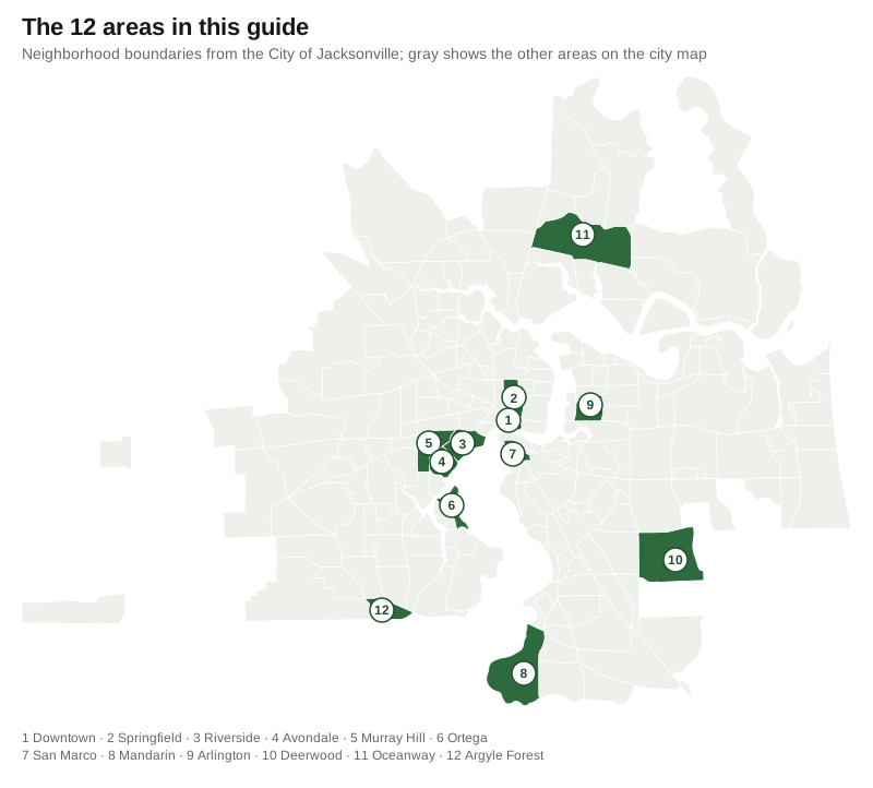
The 12 areas at a glance
| Area | Planning district | Main ZIP code | Zoned high school | Typical home value in the ZIP, Aug. 2026 |
|---|---|---|---|---|
| Downtown | Urban Core | 32202 | Raines | $155,595 |
| Springfield | Urban Core | 32206 | Raines | $129,026 |
| Riverside | Northwest | 32204 and 32205 | Riverside | $319,300 and $255,208 |
| Avondale | Southwest | 32205 | Riverside | $255,208 |
| Murray Hill | Northwest | 32205 | Riverside | $255,208 |
| Ortega | Southwest | 32210 | Riverside | $222,701 |
| San Marco | Southeast | 32207 | Terry Parker | $279,818 |
| Mandarin | Southeast | 32223 | Mandarin | $434,121 |
| Arlington | Greater Arlington/Beaches | 32211 | Terry Parker | $248,107 |
| Deerwood | Southeast | 32256 | Atlantic Coast | $309,798 |
| Oceanway | North | 32218 | First Coast | $297,186 |
| Argyle Forest | Southwest | 32244 | Westside | $255,083 |
Zillow’s figure for the city of Jacksonville as a whole was $285,103 in August 2026, down 0.8% on the year. ZIP code values cover every home in the ZIP code, so Avondale, Murray Hill and part of Riverside, which share 32205, show the same figure. Grades for every zoned school are on each area’s page. More in our home prices guide and schools guide.
Downtown and the Urban Core
Downtown is the city’s 428-acre core on the north bank, with City Hall, James Weldon Johnson Park and the Skyway. Most of its homes are condominiums and apartments.
Springfield is the 888-acre neighborhood directly north of downtown, where half the single-family homes were built in 1919 or earlier, with 18-acre Klutho Park inside it.
West bank: Riverside, Avondale, Murray Hill and Ortega
Riverside runs along the river southwest of downtown, with Memorial Park, 15 city park sites and a mix of houses, small apartment buildings and condos.
Avondale is an 880-acre neighborhood of mostly single-family homes with 27-acre Boone Park. Both of its elementary zones, Fishweir and West Riverside, were graded A for 2026.
Murray Hill lies west of both, with 3,865 single-family homes, Powers Park and the Murray Hill Art Center.
Ortega is a 663-acre neighborhood of almost all single-family homes, with seven small parks and an elementary school inside it.
All four are zoned for Riverside High.
South side: San Marco, Mandarin and Deerwood
San Marco sits across the river from downtown, with Balis Park on San Marco Square and zoned for Hendricks Avenue Elementary, graded A for 2026.
Mandarin is a 3,996-acre area in the far south on the river, almost all single-family homes, zoned for Mandarin Middle and Mandarin High, both graded A for 2026.
Deerwood is a 4,304-acre Southside area near I-295 and J. Turner Butler Boulevard, with single-family homes, 2,338 condos and 4,328 apartment units.
East, north and west
Arlington is the 902-acre neighborhood the city map labels Arlington, inside the larger Greater Arlington/Beaches planning district, with Tree Hill Nature Center.
Oceanway is a 5,149-acre Northside area, the newest-built in this guide, about 7 miles by road from Jacksonville International Airport.
Argyle Forest is a 993-acre Westside area along Argyle Forest Boulevard, zoned for Chimney Lakes Elementary, graded A for 2026.
Comparing Jacksonville with its neighbors
For tax rates, schools, home values and city services side by side with Orange Park, Atlantic Beach and Neptune Beach, see Jacksonville vs Orange Park vs Atlantic Beach vs Neptune Beach. For the full property tax picture, see our property taxes guide; for roads and transit, our getting around guide; and for setting up utilities and a Florida driver’s license, our moving here guide.
How we built this
- Areas: the boundaries are the City of Jacksonville’s own neighborhood polygons, published on its GIS site, and the planning districts are the city’s citizens planning advisory committee boundaries. We chose 12 areas that span the six districts and used the city’s names, except Argyle Forest, which the city map spells “Argyle Forrest.” OpenStreetMap labels six of the 12 by the same name inside the same boundaries.
- Homes, ZIP codes and schools: we matched the Florida Department of Revenue’s statewide parcel data, built from the Duval County Property Appraiser’s tax roll, to each area and to Duval County Public Schools’ 2026-27 attendance zone layer on Oct. 10, 2026.
- Grades: Florida Department of Education school grades for 2026.
- Home values: the Zillow Home Value Index by ZIP code for August 2026.
- Roads, buses and stores: road distances measured on the OpenStreetMap road network with the OSRM routing engine; bus stops from the Jacksonville Transportation Authority’s current schedule data; supermarkets and pharmacies from OpenStreetMap.
Map: City of Jacksonville neighborhood boundaries, drawn by Jacksonville News Now. Store and road data © OpenStreetMap contributors.
Frequently asked questions
How many neighborhoods are there in Jacksonville?
The City of Jacksonville’s neighborhood map names 206 areas in Duval County. Four of them are the separate cities of Atlantic Beach, Neptune Beach and Jacksonville Beach and the town of Baldwin, which leaves 202 inside Jacksonville. This guide covers 12.
What high school is my Jacksonville home zoned for?
It depends on the street address. Duval County Public Schools’ 2026-27 zone layer has 13 high school zones, and some Jacksonville homes are zoned for schools outside city limits, such as Fletcher High in Neptune Beach. Check an address with the district’s school locator.
Which Jacksonville neighborhood has the highest home values?
Of the areas in this guide, Mandarin’s ZIP code, 32223, had the highest Zillow Home Value Index figure in August 2026, $434,121. Zillow’s typical value for the city as a whole was $285,103.
How big is Jacksonville?
About 747 square miles of land, according to the Census Bureau, with 977,670 people in the 2020-2024 American Community Survey five-year estimates.
Have your say